In this blog we are excited to showcase examples of the NY State and NJ State opt-in for cannabis maps as well as two of the top municipalities in each state to show potential locations for legal cannabis operations. Contact us for the digital versions and immediate access to CREC Maps.
If you are an operator, landlord and/or investor, these tools can be used to create custom maps and detailed analysis for your exact needs. Helping you determine the best markets, and secure the best properties for your next licensed cannabis facility. When you subscribe to the CREC Portal, you will have access to all our custom cannabis maps, regulations info, and research tools.
The following two maps are part of our analyst’s recent updates after the Nov Election Results for Cannabis and used by our cannabis licensing experts for support in their application planning.
View these screenshots and contact us below for more information on using our digital mapping tools.
State of New York Opted-In Cannabis Map
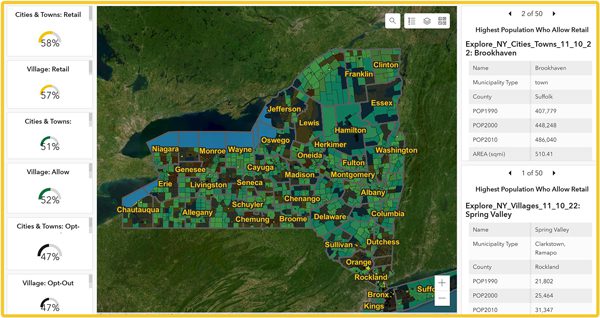
In this map you will see our custom New York State Map from the CREC Portal. You can view that 58% of New York’s Cities & Towns, and 57% of the Villages opted in to allow retail licenses. 51% of the Cities & Towns, and 52% of the Villages opted in to allow consumption lounge licenses. All other vertical uses are required to be allowed as a state requirement.
Brookhaven GreenZone Regulations Map
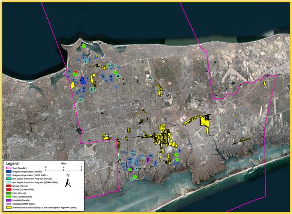
We are highlighting the City of Brookhaven, which is the second most populated city that is allowing retail licenses in the state of New York. The yellow areas represent the limited amount of GreenZones available (viable zoning) for retail licenses. The other colors represent the businesses and distances you need to be away from according to the local ordinance.
Allowable Uses
- Storefront Retail
- On Site Consumption (Accessory Use for Storefront Retail)
- Cultivator
- Processor
- Distributor
- Microbusiness
- Delivery
Setbacks:
500 ft radius of any residential use or zone.
1 mile radius between retailers.
1,000 feet of the lot line of any premises used for a school, church or other place of religious worship, park, playground, or playing field, library, hospital or similar public or semi-public place of general congregation, or non-degree-granting instruction/programs, including self-defense, dance, swimming, gymnastics, and other sports. Setbacks for non-retail uses have not yet been determined: No state standards for non-retail uses.
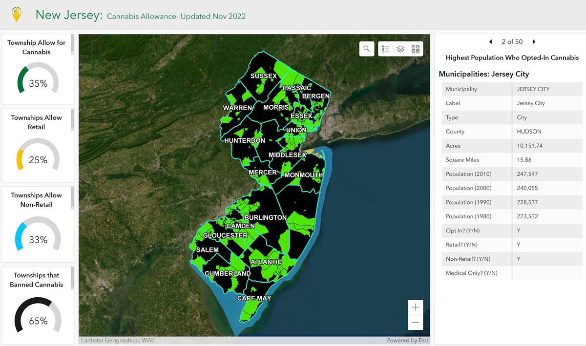
State of New Jersey Opted-In Cannabis Map
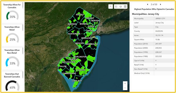
In this custom map from CREC Portal, you can view the New Jersey townships that have opted-in to allow cannabis. Out of the 565 municipalities, 26% will allow cannabis, and only 18% will allow retail for adult-use sales.
The green municipalities outlined in the map, shows the current opportunities for cannabis operations in New Jersey. Our analysts update the maps regularly to ensure accuracy and compliance to match the current state of opted-in municipalities.
Jersey City, NJ GreenZone Regulations Map
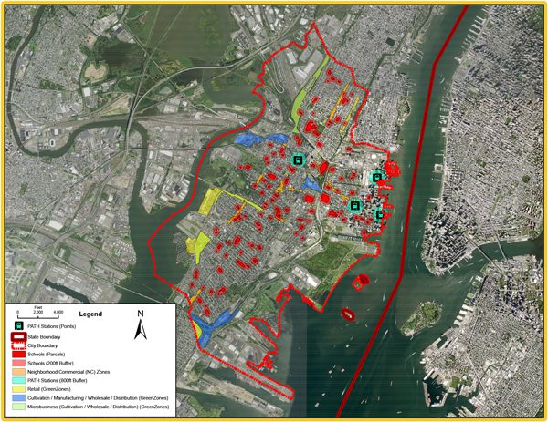
In this custom map, we are highlighting Jersey City in Hudson County, which is only 15 square miles, next to NYC, and has the second highest population of the opted-in municipalities. The yellow, green, and dark blue areas represent the limited amount of GreenZones available (viable zoning) for retail, cultivation, and microbusiness licenses.
Allowable Uses:
- Cultivation (Class 1)
- Manufacturing (Class 2)
- Wholesaler (Class 3)
- Distribution (Class 4)
- Class 5 (Retailer)
- Microbusiness
- Consumption Lounge (TBD)
Setbacks:
- Class 1-4: 200 feet from other class 1-4 business
- Class 1,3, 4 (Microbusiness): No setbacks
- Class 5: 200 feet of entry of business from from any school identified on the City’s Official Drug Free School and Park Zones Map (NOTE: this includes some daycares and child care centers)
PROPRIETARY RESEARCH TOOLS ONLY AVAILABLE BY CREC
Access agent network, proprietary research, custom maps, listings matching technology and more built to successfully complete cannabis business & real estate transactions faster!
- Interactive Research and Due Diligence Tools
- Nationwide Business & Property Listings
- Nationwide Database of Buyers and Operators
- Nationwide Network of Brokers & Consultants
- Nationwide State & Local Regulatory Maps
Custom Maps for Cannabis Businesses
![]() We build custom cannabis zoning maps for operators, landlords and/or investors to better support their cannabis business expansion, licensing, and future operations. Contact us for more information.
We build custom cannabis zoning maps for operators, landlords and/or investors to better support their cannabis business expansion, licensing, and future operations. Contact us for more information.